Protocol - Neighborhood Walking and Biking Environment
Description
MAPS-Mini is a 15-item neighborhood environment audit via GIS of a 0.25-mile walking or biking route from participant residences to the nearest nonresidential destination. The tool contains 3 items on street crossings, measured at every intersection on the route and 12 items on street segments, collected on every street block face on the route. Items were scored from 0-1 or 0-2. A total score summing all computed items for each participant represents the cumulative effect of microscale attributes of the built environment.
Specific Instructions
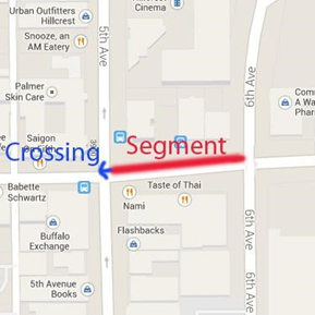
The Microscale Audit of Pedestrian Streetscapes (MAPS-Mini) can be completed by using one of two methods: route-level or segment-level data collection. A participant route will almost always start with a segment at the participant’s house. When there is no sidewalk on the participant’s side of the street, but there is one on the other side of the street, the route will start with a crossing. Segment-level data collection is completed block-by-block, and is an effective way to canvas an area. Each segment in the area is completed, as well as a crossing on one side (see example below), until the desired area is complete.
Full instructions can be found in the MAPS Data Collection and Scoring Manual:
Cain, K. L., Millstein, R. A., & Geremia, C. M. (2012). Microscale Audit of Pedestrian Streetscapes (MAPS): data collection & scoring manual. University California San Diego. Available for download at: https://drjimsallis.org/measure_maps.html#MAPSMINI
The MAPS-Mini should be administered by the study team. The questions can be completed using freely available map and street view tools, or by auditing in-person.
Please note there have been different kinds of implementation—some with remote online observers and some with Machine Learning to automate audits. When using this protocol, the user could search to identify if such data may be available for their geographic area of study.
Availability
This protocol is freely available; permission not required for use.
Protocol
MAPS Mini Survey – Segment Method
Date Auditor ID#________
Route #
Start Time: ________End Time: _______
Crossing
Intersection of ____________________&
____________________________________
Crossing from N S E W to N S E W
1. Is a pedestrian walk signal present?
[ ] 0 No
[ ] 1 Yes
2. Is there a ramp at the curb(s)?
[ ] 0 No
[ ] 1 Yes, at one curb only
[ ] 2 Yes, at both pre-crossing and post-crossing curbs
3. Is there a marked crosswalk?
[ ] 0 No
[ ] 1 Yes
Segment: *Count one (your) side of the street*
Street ______________Side N S E W
Starting Cross-street: ________________
Ending Cross-street: ________________
4. Type:
[ ] 0 Residential
[ ] 1 Commercial
5. How many public parks are present?
[ ] 0
[ ] 1
[ ] 2 or more
6. How many public transit stops are present?
[ ] 0
[ ] 1
[ ] 2 or more
7. Are there any benches or places to sit (include bus stop benches)?
[ ] 0 No
[ ] 1 Yes
8. Are street lights installed?
[ ] 0 None
[ ] 1 Some
[ ] 2 Ample
9. Are the buildings well maintained?
[ ] 0 0-99%
[ ] 1 100%
10. Is graffiti/tagging present (do not include murals)?
[ ] 1 No
[ ] 0 Yes
11. Is there a designated bike path?
[ ] 0 No
[ ] 1 Painted line
[ ] 2 Physical barrier
12. Is a sidewalk present? If no, skip to 12
[ ] 0 No
[ ] 1 Yes
13. Are there poorly maintained sections of the sidewalk that constitute major trip hazards? (e.g. heaves, misalignment, cracks, overgrowth, incomplete sidewalk)
[ ] 1 None
[ ] 0 Any/no sidewalk present
14. Is a buffer present?
[ ] 0 No/no sidewalk present
[ ] 1 Yes
15. What percentage of the length of the sidewalk/walkway is covered by trees, awnings or other overhead coverage?
[ ] 0 0-25% / no sidewalk
[ ] 1 26-75%
[ ] 2 76-100%
Score = Total Points____/21 = ____%
Scoring Instructions
Grand_Score
Compute an overall score by summing all of the above items:
4 + 5 + 6 + 7 + 8 + 9 + S7 + 10 + 11 + 12 + 13 + 14 + 1 + 2 + 3
Grand_Score_Percent
Compute the percent of total possible points:
Grand_Score/21
See the MAPS-Mini data dictionary – segment method for detailed variable names and item-level coding. Scores from the individual items are averaged across street segments and crossings to compute participant-level scores. The total score is the sum of all computed items for each participant, expressed as a percent of total possible points, and indicates environmental support of active transport. A second scoring method is the “percentage of possible maximum score,” which is more easily interpretable and allows for comparison of scores across different versions.
Personnel and Training Required
Data collection training and certification involving 1 day of in-office training, and 2 days of field training. To be certified to rate independently, data collectors had to complete at least four route assessments with reliability
≥95% with the trainer.
Equipment Needs
GIS software including tax assessor and ESRI parcel layers; computer with access to the Internet for Google Maps, basic web searches for location name/address; Network Analyst software for identifying the shortest route from a participant’s home to the nearest eligible destination.
Requirements
| Requirement Category | Required |
|---|---|
| Major equipment | No |
| Specialized training | Yes |
| Specialized requirements for biospecimen collection | No |
| Average time of greater than 15 minutes in an unaffected individual | No |
Mode of Administration
GIS-based Analysis
Lifestage
Not applicable
Participants
Not applicable
Selection Rationale
MAPS-Mini is validated in multiple populations and settings, and for in-person and automated audits. It is low burden to participants.
Language
English
Standards
| Standard | Name | ID | Source |
|---|---|---|---|
| caDSR Form | PX291001 Neighborhood Walking Biking Environment | 14425334 | caDSR Form |
Derived Variables
None
Process and Review
Not applicable
Protocol Name from Source
Microscale Audit of Pedestrian Streetscapes (MAPS-Mini)
Source
Cain, K. L., Gavand, K. A., Conway, T. L., Geremia, C. M., Millstein, R. A., Frank, L. D., Saelens, B. E., Adams, M. A., Glanz, K., King, A. C., & Sallis, J. F. (2017). Developing and validating an abbreviated version of the Microscale Audit for Pedestrian Streetscapes (MAPS-Abbreviated). Journal of Transport & Health, 5, 84–96. https://doi.org/ 101016/j.jth.2017.05.004
Sallis, J. F., Cain, K. L., Conway, T. L., Gavand, K. A., Millstein, R. A., Geremia, C. M., Frank, L. D., Saelens, B. E., Glanz, K., & King, A. C. (2015). Is your neighborhood designed to support physical activity? a brief streetscape audit tool. Preventing Chronic Disease, 12, E141. https://doi.org/10.5888/pcd12.150098
General References
Fox, E. H., Chapman, J. E., Moland, A. M., Alfonsin, N. E., Frank, L. D., Sallis, J. F., Conway, T. L., Cain, K. L., Geremia, C., Cerin, E., Vanwolleghem, G., Van Dyck, D., Queralt, A., Molina-García, J., Hino, A., Lopes, A., Salmon, J., Timperio, A., & Kershaw, S. E. (2021). International evaluation of the Microscale Audit of Pedestrian Streetscapes (MAPS) Global instrument: comparative assessment between local and remote online observers. International Journal of Behavioral Nutrition and Physical Activity, 18(1), 84. https://doi.org/10.1186/s12966-021-01146-3
Koo, B. W., Guhathakurta, S., & Botchwey, N. (2022). Development and validation of automated microscale walkability audit method. Health & Place, 73, 102733. https://doi.org/10.1016/j.healthplace.2021.102733
Protocol ID
291001
Variables
Export Variables| Variable Name | Variable ID | Variable Description | dbGaP Mapping | |
|---|---|---|---|---|
| PX291001_Neighborhood_Walking_Biking_Environment_Auditor_ID | ||||
| PX291001020000 | Auditor ID# | N/A | ||
| PX291001_Neighborhood_Walking_Biking_Environment_Benches_Places_Sit | ||||
| PX291001150000 | Are there any benches or places to sit more | N/A | ||
| PX291001_Neighborhood_Walking_Biking_Environment_Buffer | ||||
| PX291001110000 | Is a buffer present? | N/A | ||
| PX291001_Neighborhood_Walking_Biking_Environment_Buildings_Well_Maintained | ||||
| PX291001170000 | Are the buildings well maintained? | N/A | ||
| PX291001_Neighborhood_Walking_Biking_Environment_Crossing_From | ||||
| PX291001070100 | Crossing from | N/A | ||
| PX291001_Neighborhood_Walking_Biking_Environment_Crossing_To | ||||
| PX291001070200 | Crossing to | N/A | ||
| PX291001_Neighborhood_Walking_Biking_Environment_Cross_Street_End | ||||
| PX291001120200 | Ending Cross-street | N/A | ||
| PX291001_Neighborhood_Walking_Biking_Environment_Cross_Street_Start | ||||
| PX291001120100 | Starting Cross-street | N/A | ||
| PX291001_Neighborhood_Walking_Biking_Environment_Cross_Street_Type | ||||
| PX291001120300 | Type | N/A | ||
| PX291001_Neighborhood_Walking_Biking_Environment_Date | ||||
| PX291001010000 | Date | N/A | ||
| PX291001_Neighborhood_Walking_Biking_Environment_Designated_Bike_Path | ||||
| PX291001190000 | Is there a designated bike path? | N/A | ||
| PX291001_Neighborhood_Walking_Biking_Environment_End_Time | ||||
| PX291001050000 | End Time | N/A | ||
| PX291001_Neighborhood_Walking_Biking_Environment_Graffiti_Tagging | ||||
| PX291001180000 | Is graffiti/tagging present (do not include more | N/A | ||
| PX291001_Neighborhood_Walking_Biking_Environment_Intersection_Street_1 | ||||
| PX291001060100 | Intersection Street 1 | N/A | ||
| PX291001_Neighborhood_Walking_Biking_Environment_Intersection_Street_2 | ||||
| PX291001060200 | Intersection Street 2 | N/A | ||
| PX291001_Neighborhood_Walking_Biking_Environment_Marked_Crosswalk | ||||
| PX291001100000 | Is there a marked crosswalk? | N/A | ||
| PX291001_Neighborhood_Walking_Biking_Environment_Number_Public_Parks | ||||
| PX291001130000 | How many public parks are present? | N/A | ||
| PX291001_Neighborhood_Walking_Biking_Environment_Number_Public_Transit_Stops | ||||
| PX291001140000 | How many public transit stops are present? | N/A | ||
| PX291001_Neighborhood_Walking_Biking_Environment_Pedestrian_Walk_Signal | ||||
| PX291001080000 | Is a pedestrian walk signal present? | N/A | ||
| PX291001_Neighborhood_Walking_Biking_Environment_Percentage_Length_Path_Covered_Overhead | ||||
| PX291001120000 | What percentage of the length of the more | N/A | ||
| PX291001_Neighborhood_Walking_Biking_Environment_Ramp_Curb | ||||
| PX291001090000 | Is there a ramp at the curb(s)? | N/A | ||
| PX291001_Neighborhood_Walking_Biking_Environment_Route_Number | ||||
| PX291001030000 | Route # | N/A | ||
| PX291001_Neighborhood_Walking_Biking_Environment_Segment_Side | ||||
| PX291001110200 | Side | N/A | ||
| PX291001_Neighborhood_Walking_Biking_Environment_Segment_Street | ||||
| PX291001110100 | Street | N/A | ||
| PX291001_Neighborhood_Walking_Biking_Environment_Sidewalk | ||||
| PX291001100100 | Is a sidewalk present? | N/A | ||
| PX291001_Neighborhood_Walking_Biking_Environment_Sidewalk_Poorly_Maintained | ||||
| PX291001100200 | Are there poorly maintained sections of the more | N/A | ||
| PX291001_Neighborhood_Walking_Biking_Environment_Start_Time | ||||
| PX291001040000 | Start Time | N/A | ||
| PX291001_Neighborhood_Walking_Biking_Environment_Street_Lights | ||||
| PX291001160000 | Are street lights installed? | N/A | ||
Measure Name
Neighborhood Walking and Biking Environment
Release Date
December 14, 2022
Definition
Neighborhood Walking and Biking Environment encompasses the quality of the walking and biking environment and conditions, including safety, comfort, and convenience, near an individual’s neighborhood.
Purpose
Walkability has been associated with increased walking behavior and physical activity, and is a protective factor for chronic diseases, such as obesity and diabetes, and depression. It has been found to have associations with cognitive functioning.
Keywords
Walking, walking behavior, obesity, diabetes, depression, cognitive functioning, physical activity, neighborhood, environment, built environment, automated audit, pedestrian audit, microscale, remote data collection, neighborhood built environment
Measure Protocols
| Protocol ID | Protocol Name |
|---|---|
| 291001 | Neighborhood Walking and Biking Environment |